The Mounds of Kish
The place we know today as "Kish" actually consists of many different mounds, spread over a wide area. Visitors can tour both Tell Uhaimir, just off Highway 1 between Babylon and Baghdad, and Tell Ingharra, further west along the access road. We have written these pages to help visitors make sense of what they see, and for people who cannot visit to better imagine the current conditions on site.
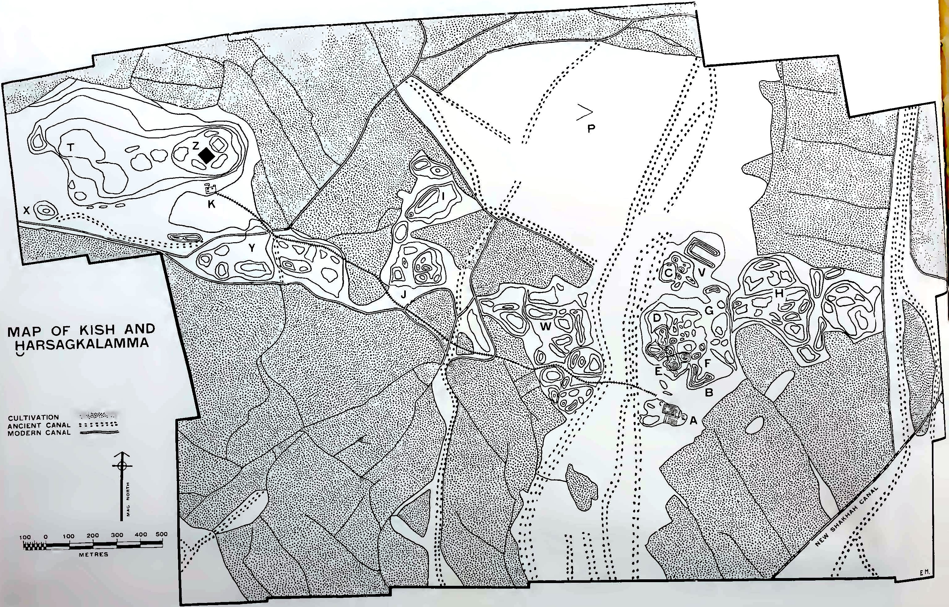 [/kish/images/mackay-kish-map.jpg]
The mounds of Kish, showing the names given to them by the Oxford-Field Museum Expedition; the surrounding fields and date orchards under cultivation in the 1920s; and the dry bed of the ancient river channel. Source: Mackay 1929: frontispiece, drawn by Dorothy Mackay.
- The site of Kish
- The site of Kish takes the name of the ancient city which once stood over the western portion of the site, Tell Uhaimir. Its twin city Hursagkalama, less than 2 km away on Tell Ingharra, was set to the east. It is this part of the site that attracts most visitors today. In addition, several central mounds have yielded important archaeological finds over the years.
Tell Uhaimir (west Kish, ancient Kish)
See Mounds K, T, X, Y and Z on the map..
- The ziggurat of Zababa (Mound Z)
- Tell Uhaimir, the "little red tell", is easily identifiable by its colour. Today, it can still be seen from the road, rising above the archaeological site of Kish. This mound is artificial: the accumulated debris hides a ziggurat tower dedicated to Zababa, god of war. In ancient times, this ziggurat must have been visible from far away, standing over the western portion of the city. It was a symbol of Kish's power, and of its god.
- The Town Site, or House Ruins (Mound T)
- The phrase "town site" or "house ruins" refers to the remains of houses found close to the ziggurat of Zababa. Tablets sold on the antiquities market before 1912 are believed to have come from this area. Both Genouillac and the OFME also found Old Babylonian tablets here, including evidence of home-schooling from the 18th century BC.
- The Fortress (Mound X)
- Between 1923 and 1924, the OFME unearthed a fortress and its large buttressed rampart on this mound, which they dated to the second half of the first millennium BC.
- Tell Khazna
- Tell Khazna (not shown in Fig. 1) is to the west of Tell Uhaimir, on the other side of Highway 1. It is most notable for the many sherds of pottery found there, dating to the early Islamic to late Abbasid periods.
Tell Ingharra (east Kish, ancient Hursagkalama)
See Mounds A-H on the map. After this map was made, Watelin dug Trench Y to the southwest of mound E.
- The Temple of Ishtar (Mound E)
- The monumental building located a few steps away from the main entrance to Tell Ingharra was once a temple of the great goddess Ishtar. In ancient Iraq, temples were not only holy places in which gods and goddesses were worshipped but also their homes. Ishtar's home at Kish had the Sumerian name E-hursag-kalama, "House, Mountain of the Land". The version of the temple that visitors can see today was commissioned by a Babylonian king in the 6th century BC but never finished.
- The two ziggurats on Tell Ingharra (Mounds B and F)
- Tell Ingharra is home to two ziggurats: a large one set on the southwest side of the temple of Ishtar and a small one on its southeast side. But these ziggurats are much, much older than the temple. They were built during the Early Dynastic period (2900-2334 BC), at the same time as other monumental buildings like the Sumerian Palace.
- The Sumerian Palace (Mound A)
- Mound A is the name given to what was once a low and irregular mound, close to the large ziggurat of the temple of Ishtar on Tell Ingharra. When it was excavated by the OFME from 1923, this mound became famous as the location of a sumptuous Sumerian palace, dating to the Early Dynastic III period, c. 2500 BC. An extensive cemetery was also discovered on top of the palace walls, used for a short period after the palace was abandoned.
- The Chariot Burials (Trench Y)
- The "Chariot Burials" or "Cart burials" are a group of graves discovered on Tell Ingharra in 1928-1929 by the OFME, in front of the large ziggurat of Ishtar's temple. They contained the human remains of riders laid next to their equids and chariots. Dated to the Early Dynastic I-IIIa periods (2900-2370 BC), these graves are considered the direct predecessors of the "Royal Tombs" at Ur.
- Babylonian Home Schooling at Tell Ingharra (Trench C)
- To explore the stratigraphy of Tell Ingharra, the OFME dug a series of deep trenches in front of the northwest entrance of the Temple of Ishtar, collectively known as Trench C . This area yielded numerous cuneiform tablets, including letters, contracts, and accounts, but also exercises written in the course of home-schooling in the 18th century BC.
- Sassanian Villas or Palaces (Mounds G-H)
- During the Sassanian period (226–651 AD), some of Kish's inhabitants built seven large villas or palaces, richly decorated with stucco plaques. These spectacular buildings were unearthed by the OFME between 1931 and 1933, though little remains of them on the site today.
The central mounds
See Mounds I, J, P, V, and W on the map.
- Tell Hudhr (Mound I)
- The French Assyriologist Henri de Genouillac and his team camped on this mound during their excavations of 1912. The site has not been systematically explored, but finds here date from the Old Babylonian to late Abbasid periods (c.18th century BC to 13th century AD).
- The Plano-Convex Building: An Administrative Building in Area P
- In 1923-1924, the OFME discovered a large building north of Tell Ingharra, entirely made of plano-convex bricks — that is, bricks with one flat, rectangular surface and the other surfaces curved. Although the OFME's published reports barely mention this find, archaeologists now consider Area P to be one of the most important areas of the site, as it provides evidence of a major urban settlement from the Early Dynastic period, or early third millennium BC.
- Tell Bandar (Mound V)
- Tell Bandar ("the harbour mound" in Arabic) is a small, U-shaped tell visible from the top of Tell Ingharra's large ziggurat. Also called "Mound V" by archaeologists, it has a long history of occupation, dating back to the Early Dynastic period, or early third millennium BCE. However, its current shape derives from the substantial ruins of a fortress and a tower from the Parthian period (2nd century BC - 2nd century AD).
- The Tablet Mound (Mound W) and the so-called "Library"
- The large mound to the west of Tell Ingharra is known as Mound W , or more informally as Tell Antika, "Mound of Antiquities" or the "Tablet Mound". Here in 1924, the OFME discovered hundreds of cuneiform tablets from the Neo-Babylonian period (mid-first century BC) which they thought must have made up a "library".
30 Oct 2025
Nadia Aït Saïd-Ghanem & Eleanor Robson
Nadia Aït Saïd-Ghanem & Eleanor Robson, 'The Mounds of Kish', The Forgotten City of Kish • مدينة كيش المنسية, The Kish Project, 2025 [http://oracc.org/MoundsofKish/]