Kish, Its Place and History
 [/kish/fieldmus/images/MAP1-large.jpg]
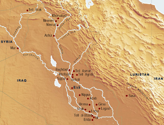
Map of Ancient Mesopotamia. Courtesy of the Oriental Institute Museum.
The archaeological site of Kish (32° 30' N, 44° 35' E) is located on the floodplain of the Euphrates River in modern Iraq, twelve kilometers due east of ancient Babylon and eighty kilometers south of Baghdad.
The site is made up of more than forty mounds scattered over a twenty-four-square-kilometer area divided by the ancient course of the Euphrates River (the Puratta) into eastern and western portions. The eastern complex (known in ancient times as Hursagkalama) is dominated by a series of mounds known as Ingharra, while the ziggurat (stepped temple tower) of Uhaimir towers over the western remains of the city.
 [/kish/fieldmus/images/MAP2-large.jpg]
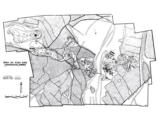
Map of Kish and Hursagkalamma. From Mackay, 1931:2, frontispiece.
The geographic situation of Kish, on the banks of the Euphrates, the region's main riverine artery, and near the convergence of major interregional road systems, gave its early settlers numerous advantages. According to the Sumerian King List, Kish was the first seat of kingship founded after the great flood, and archaeologists now recognize the site as one of the earliest cities in the world, and the region's first true hegemon.
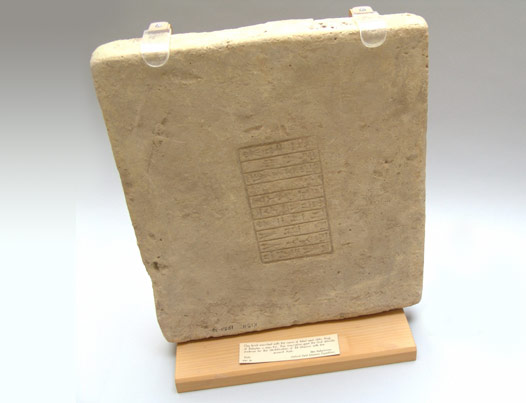
 [/kish/fieldmus/images/KPH-large.jpg]
Tablets found at Jamdat Nasr date to an early stage in the development of Mesopotamian cuneiform script and are difficult to translate. This tablet seems to be an accounting, perhaps for the length of one year, of various commodities that were stored or distributed in different types of vessels. In the lower right-hand corner of the tablet is the pictogram for "to eat," which combines a bowl and the profile view of a human head. At the top of the same block of text is the sign thought to represent the name of the ancient city whose ruins are now known as Jamdat Nasr.
Jamdat Nasr. Clay. Jamdat Nasr Period. Ashmolean Museum 1926.564
In the early 3rd millennium B.C., the socio-political landscape of southern Iraq was characterized by the presence of a number of small competing city-states. These polities were sustained by swathes of land irrigated by major canals feeding from the Tigris and Euphrates, and were controlled by local petty monarchs. These rulers were able to raise armies when conflict arose with neighboring city-states and had ties to local cults or religious establishments. In this highly fractious environment Kish emerged as the most influential city-state in the region in the earliest part of the 3rd millennium B.C. (known as the Early Dynastic period). The city appears eventually to have wielded control over not just its immediate environs, but the whole of Sumer and Akkad.
Sculptures and archaic tablets found during excavations attest to the existence of a fully developed administration at the site by the last quarter of the fourth millennium. Within two or three hundred years, the settlement had grown and its rulers were able to establish themselves as major political figures.
 [/kish/fieldmus/images/KPH2-large.jpg]
On this brick, King Adad-apla-iddina commemorated his rebuilding of E-me-te-ur-sag, the sacred precinct of the god Zababa at Kish. Zababa was a war god, sometimes described as 'sharp-horned,' whose symbol was a bird-headed scepter or mace.
Kish West, Uhaimir, Mound Z, Ziggurat. Baked clay. Second Dynasty of Isin. Field Museum 156011
The explanation for the city's rise likely is to be found at the intersection of geography and religion. At the time of its primacy, the Tigris and Euphrates Rivers were separated at Kish by only 30-40 miles. Thus, control of the land of Kish afforded dominance over the rivers, and thus control of irrigation to fields and cities downstream and the best means of moving soldiers throughout the country.
Moreover, Kish was enshrined in Mesopotamian tradition as the first city to exercise political control over the entirety of Sumer and Akkad after the great flood that destroyed the world. This places the ascendancy of Kish in the middle of a long sequence of cultural innovations in greater Mesopotamia, a region stretching from Anatolia to modern Iran. Over a period of some 8-10,000 years, this area saw the development of some of the earliest sedentary villages in the world, the domestication of a substantial number of faunal and floral species (including barley, wheat, sheep, and goat), and the emergence of social complexity, giving rise, in fits and spurts, to the development of chiefdoms, states, and eventually empires that controlled huge swathes of the ancient Near East.
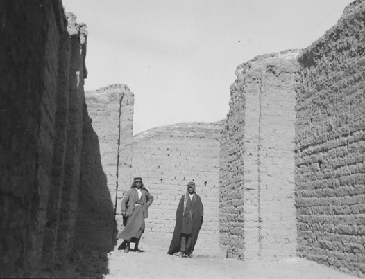 [/kish/fieldmus/images/KPH3-large.jpg]
The mudbrick walls of the Neo-Babylonian Temple on Ingharra were preserved to a remarkable height, as is evident in this photograph. The Kish Expedition cleared some 40 rooms of this structure, but found nothing that gave the name of the king who constructed it or of the deity to whom it was dedicated.
Kish East, Ingharra, Neo-Babylonian Temple. 1926-28 Seasons. Negative 59603.
While the actual regulatory power of the city of Kish waned during the Akkadian period, when King Naram-Sin was forced to quell a rebellion there (ca. 2250 B.C.), its cachet as the first major regional seat of power lingered for centuries. This is best demonstrated by the fact that leaders of other cities who aspired to regional leadership were anxious to add the title "King of Kish" to their list of names, as the possession of this honorific lent added legitimacy to their claims of power. The title seems to have functioned in much the same manner as the later Medieval "Holy Roman Emperor."
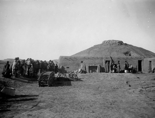 [/kish/fieldmus/images/KPH4-large.jpg]
This photograph shows the Kish Expedition camp, with workmen lined up on the left to receive payment from someone (probably the field director, Ernest Mackay) seated at a table on the right. They are receiving either their wages or bakshish—extra payment for objects they unearthed during the course of the excavations.
Kish West, Mound K with Mound Z in the Background. 1924-25 Season. Oxford Negative 426
Despite this powerful association with the concept of kingship, the fortunes of the city of Kish waxed and waned throughout the following millennia. During the Akkadian period (2330-2150 B.C.), the city's power declined as the center of regional political gravity shifted to Akkad. This regression continued into Old Babylonian times (2000-1600 B.C.), although the significance of Kish later rebounded, and the city and region continued to prosper well into the Sasanian period during the first centuries of this era. The total occupation of Kish spans four millennia, and the excavated collections include artifacts from the Jamdat Nasr through Sasanian periods (ca. 3200 B.C.-7th century A.D.) as well as medieval ceramics (late 10th to early 14th centuries A.D.). As such, the collections serve as a chronostratigraphic key to understanding the history of Mesopotamia.
The Field Museum
The Field Museum, 'Kish, Its Place and History', The Field Museum's Kish Database Project, 2004-09, The Field Museum, 2025 [http://oracc.org/kish/fieldmus/KishPast,PresentandFuture/Kish,ItsPlaceandHistory/]